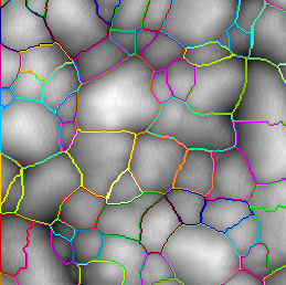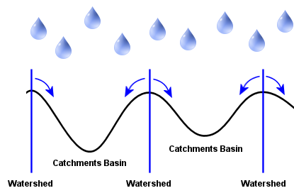
Basic watershed segmentation is provided by the Watershed – Packed Features Detect Method. This method can also be explained by a metaphor based on the behavior of water in a landscape. When it rains, drops of water falling in different regions will follow the landscape downhill. The water will end up at the bottom of valleys. In this case we do not consider the depth of the resulting lakes in the valleys. So the Shapes are defined by:
For each valley there will be a region from which all water drains into it. In other words: each valley is associated with a catchments basin, and each point in the landscape belongs to exactly one unique basin.
All generated Shapes are by definition Pores. In Particle mode the image is inverted behind the scenes, which is the case in the example below: